Trail On foot Manerba del Garda - rocca di manerba - Photo
 Matamimi
Matamimi

User

© OpenStreetMap contributors
Length
Length
4.8 km
Max alt
Max alt
195 m
Uphill gradient
Uphill gradient
159 m
Km-Effort
Km-Effort  
7 km
Min alt
Min alt
62 m
Downhill gradient
Downhill gradient
164 m
Boucle
Boucle
Yes
Creation date :
2021-06-05 18:12:52.747
Updated on :
2021-06-05 18:29:05.336

(0 Reviews)

On foot
On foot
1h35
Difficulty : Medium

Scan this QR Code to open this trail in the SityTrail application

FREE GPS app for hiking

Logo SityTrail SityTrail

IGN / Geographical institutes

Download SityTrail from the App Store Download SityTrail from Google Play

Logo SityTrail SityTrail World

The world is yours!

Download SityTrail from the App Store Download SityTrail from Google Play Download SityTrail on Huawei AppGallery

About

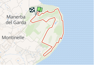
Trail On foot of 4.8 km to be discovered at Lombardy, Brescia, Manerba del Garda. This trail is proposed by Matamimi.

Description

réserve naturelle classée Patrimoine Mondial de l’UNESCO

Elevation profile

Positioning

Country:
Italy
Region :
Lombardy
Department/Province :
Brescia
Municipality :
Manerba del Garda
Location:
Unknown
Start:(UTM)
622475 ; 5046027 (32T) N.

Trails nearby

Trail On foot Puegnago del Garda - Raccordo 801 con LL - Photo
On foot
GUIDE+

On foot

Easy
Puegnago del Garda, Lombardy, Brescia, Italy
5.3 km | 7.3 km-effort
1h 39min
No
Trail Motor Moniga del Garda - a-italie-monte-baldo - Photo
Motor
gpstracks

Motor

Very easy
Moniga del Garda, Lombardy, Brescia, Italy
145 km | 245 km-effort
Unknown
Yes
Trail On foot San Felice del Benaco - portese et point de vue chiesa di san fermo - Photo
On foot
Matamimi

On foot

Easy
San Felice del Benaco, Lombardy, Brescia, Italy
4.7 km | 5.8 km-effort
1h 18min
Yes


Close
My subscriptions